Political - Best Seller!
Beschreibung:
A full classroom package:
A Political Globe and a U.S./World Political Combo Map
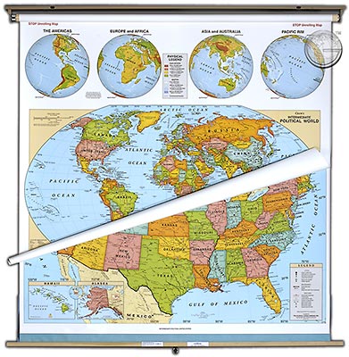
The Political U.S. and World Maps are indispensable
classroom references offering students a wealth of
geographical information. Contrasting colors make locating
places easy. Cities, capitols, countries, mountain ranges,
rivers, lakes, deserts and dozens of other details are
named. Our new world political map uses the Winkel
Projection, recognized as providing the best balance of
size, shape, and direction - the most accurate image of
the world available! Up-to-the-moment information on
national boundaries and country names is used. Printed
on non-tear material and mounted on heavy duty rollers
in brackets with backboard. 51" x 51" Markable.
A full classroom package:
A Political Globe and a U.S./World Political Combo Map
The Political U.S. and World Maps are indispensable
classroom references offering students a wealth of
geographical information. Contrasting colors make locating
places easy. Cities, capitols, countries, mountain ranges,
rivers, lakes, deserts and dozens of other details are
named. Our new world political map uses the Winkel
Projection, recognized as providing the best balance of
size, shape, and direction - the most accurate image of
the world available! Up-to-the-moment information on
national boundaries and country names is used. Printed
on non-tear material and mounted on heavy duty rollers
in brackets with backboard. 51" x 51" Markable.
Unsere unschlagbare Preis-Politik:
Beste Qualität zum günstigsten Preis!
Bestellformular Download
Was ist eine Echtholzbestäbung?
Was ist ein Springroller?
Verfügbare Versionen:
Political - Best Seller!
(Artikel-Nr.: 100014841)
(Artikel-Nr.: 100014841)
USD 279,00
